DECISIONS made a century ago still wreak consequences upon the mouth of the Myall River.
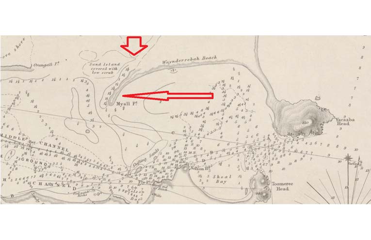
Maps from the National Library of Australia’s Trove clearly show that, in 1845, a large peninsula jutted from the western end of Winda Woppa, known as ‘Myall Point’.
 Advertise with News of The Area today.
It’s worth it for your business.
Message us.
Phone us – (02) 4981 8882.
Email us – media@newsofthearea.com.au
“It stretched over 2km from Winda Woppa and marked the designated navigation channel to the port of Tea Gardens… before overdevelopment and a cyclone wiped it out,” Gordon Grainger of the Myall River Action Group (MRAG) told NOTA.
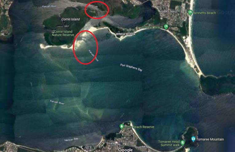
Google Maps’ satellite shows the present sand build-up, likely the remnants of the once prominent Point.
“The eastern entrance, girded by Myall Point, was the original, natural entrance to the Myall River, and it appears that Mother Nature is attempting to rebuild the Point.”
“The ‘Eastern Channel’, what many call the ‘Shortcut’, is actually the original, natural entrance to the river,” Mr Grainger informed NOTA.
“In the early 1900s, Myall Point proved unnavigable for steam ships coming into Tea Gardens for timber, so Corrie Creek was dredged to get the wood to Pindimar Bay instead.”
“The passage between Corrie Island and the mainland, or ‘western channel’, is the result of dredging Corrie Creek,” said Mr Grainger, referring to the original tidal marsh that once existed where the Corrie Channel is now.
“The Corrie Channel flows due west, the only river mouth on the eastern seaboard to do so, a very unnatural situation that stops new oceanic water from entering the river system,” Mr Grainger explained.
“This means prolonged desalination, among other environmental catastrophes.”
It would seem, therefore, that the ‘shortcut’ is, in fact, the ‘Natural Entrance’, while the ‘Corrie Channel’ is an artificial aberration.
“MRAG contends that a permanent, eastern Natural Channel should resume its ‘designated navigation’ title, hence the responsibility of State and Federal Governments,” Mr Grainger stated.
MRAG believes basic physics would also indicate that the tidal currents are presently halved between the natural and artificial channels, killing the river’s natural self-clearing ability.
By Thomas O’KEEFE