MISINFORMATION on social media during emergencies continues to rob emergency services of valuable resources when they are needed most.
The recent heavy rains across NSW saw, among the real floods and downed trees, a deluge of insidiously deliberate misinformation, such as posts suggesting that senior citizens were being forcibly evacuated from nursing homes amid the storms.
 Advertise with News of The Area today.
It’s worth it for your business.
Message us.
Phone us – (02) 4981 8882.
Email us – media@newsofthearea.com.au
NOTA contacted the nursing home in question to confirm that no such evacuation was in progress, however they had been fielding several frantic calls from loved ones attempting to discern the whereabouts and safety of their family members.
Further misinformation led many locals to believe that the only roads in and out of towns, like the Myall Way or Pindimar Road, were closed to all traffic, which was patently untrue, but caused panic nonetheless.
The problem is rife and widespread, but begins with the average reader willingly believing anything they see posted online as the unassailable truth, forgetting that anyone can post anything on social media.
“Emergency services must escalate false information in order to identify the perpetrator, which causes operations to waste precious time and attention that could be going to more practical matters,” one emergency services worker explained.
“The problem spreads because people who are elsewhere want to know what is going on, and phone lines get blocked.”
“Go to a source of truth – Bureau Of Meteorology, ABC Radio, Hazards Near Me app – the information is verified as correct, and if it is incorrect, it will be fixed, as the situation may rapidly change on the ground.”
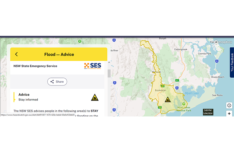
On Friday 5 April, the worst day of last week’s storms, the Hazards Near Me app clearly showed that the situation encompassing the rivers at Bulahdelah, Nerong, Markwell and Crawford rated as ‘Advice – Stay informed’, with “predicted dangerous minor flooding”.
There was no mention of evacuations, nor roads closing unnecessarily.
Locals can also immunise themselves against misinformation scams by making themselves aware of the general topographical and geographical situation around their homes.
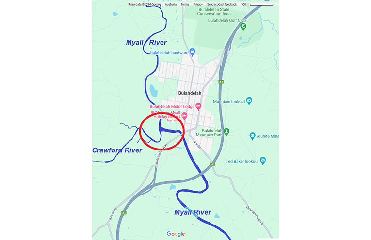
The Myall River confluence with the Crawford River at Bulahdelah means significant riverine flooding is likely in heavy rainfall.
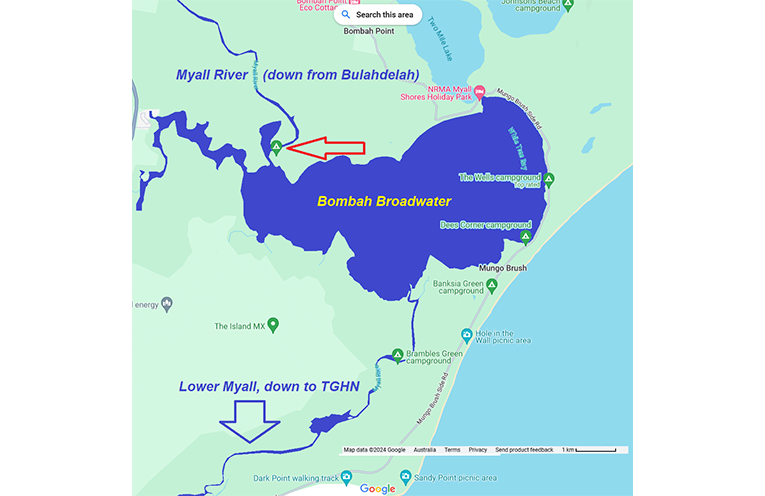
The presence of the Broadwater downstream means that freshwater rushing in will spread out widely, preventing riverine flooding in estuarine areas like Tea Gardens/Hawks Nest.
Such areas are, however, prone to flash flooding, and the location of flood markers should be noted well and often by locals and motorists.
Stroud’s section of the Karuah River has fewer doglegs and bottlenecks than other rivers, meaning that Stroud’s flood situation is separate from other localities in the region.
By Thomas O’KEEFE