Why North Arm Cove was ever conceived in the first place

The ‘Inland Way’ was supposed to lead to the Port Stephens City docks and railway interchange.

THE GENESIS of the North Arm Cove Paper Subdivision was grand speculation to make Port Stephens into a major city, perhaps one day to rival even Sydney.

‘Port Stephens City’, the moniker for the would-be metropolis at North Arm Cove, gained first real traction after the 1911 NSW Royal Commission as to Decentralisation in Railway Transit mooted the idea of extending the state’s railway from either Tarro or Stroud.

Marine Rescue - Port StephensAdvertise with News of The Area today.
It’s worth it for your business.
Message us.
Phone us – (02) 4981 8882.
Email us – media@newsofthearea.com.au

‘Decentralisation’ encouraged Australian residents to move away from overcrowded capital cities, and in the ‘Age of Rail’, a railway interchange was the keystone concept making Port Stephens City seem realistic.

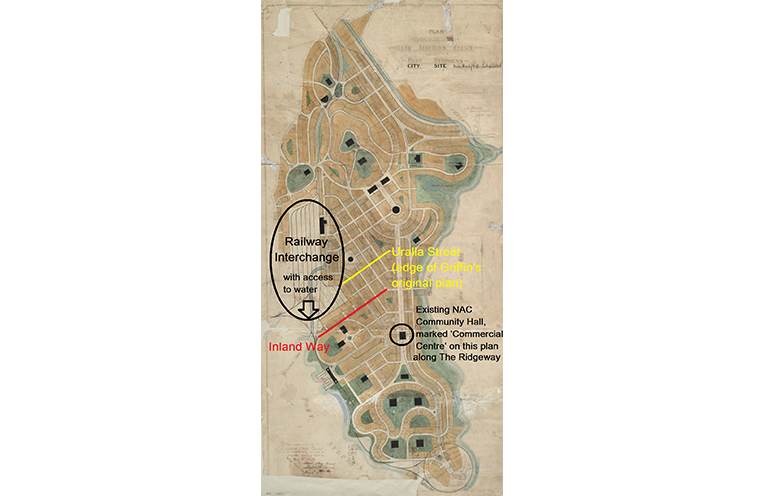
In 1917, influential politician Austin Chapman, whose company Land Limited owned land at North Arm Cove, asked acquaintances Walter Burley and Marion Mahoney Griffin (who had won the Canberra design competition years earlier) to design a city there, complete trademark sweeping curvilinear streets, rail interchange and port access.

“All of the evidence points to Port Stephens City being a speculative subdivision.

“Its then owner, Land Limited, hoped to profit from proposals for Port Stephens to become a naval base and a port for a decentralised Northern NSW,” North Arm Cove Community Association Inc President Bob Reid, who has researched the history extensively, told NOTA.

Mr Reid cites persuasive real estate journals of the time, which stated that “early real estate investment in the city site will be likely to be extremely profitable”, and “the investor will be standing on velvet of the thickest pile”.

Stroud Shire Council approved the Griffins’ plan in 1918, and physical subdivision and road marking began.

“The Griffin plan for Port Stephens City was never built, within a year the land was taken over by developer Henry Halloran, who substantially changed it into a waterside parkland into waterfront residential lots,” Mr Reid explained.

After Land Limited’s liquidation in 1919, Halloran more than doubled the size of the paper subdivision, incorporating his preferred ‘wheel-spoke’ layouts extending to the Pacific Highway.

That same year, Royal Navy Admiral Lord Jellicoe’s voice was added to many other ‘Weighty Opinions of Prominent Men’ in Halloran’s 1920 sales catalogue, recommending Port Stephens as “one of the principal Docking Bases in Australia”, while Rear Admiral Creswell had claimed it “an excellent place for a destroyer and torpedo base”.

“Port Stephens will ultimately become the chief Naval Base,” he said.

By Thomas O’KEEFE

Annotated map of the approved 1918 city plan, everything north of Uralla Street was added by Halloran, everything south was the Griffins’.

4 thoughts on “Why North Arm Cove was ever conceived in the first place

  1. Parts of this article are based on poor research and factually incorrect. Better information with relevant references could be found on Wikipedia.
    Port Stephens City, as well as Castlecrag in Sydney after that, was an attempt to do town planning in a better way than land speculation.
    From Marion Mahony Griffin’s unpublished biography of Walter Burley:
    Marion Mahony Griffin has prepared but never published memoir/biography “Magic of America”. According to her, it was Griffin’s idea to propose Port Stephens City as a New York of Australia – deep sea port with possible rail link to hinterland – like New York is for American eastern seaboard. Marion wrote:
    “When Griffin landed in Australia he immediately started on his quest. He presently made up his mind to two things of preeminent importance;—
    – 1st the ultimate, since it was the correct, location of the Federal Capital …
    – 2nd the location of the eastern port of Australia as New York is the Eastern Port of the United States. Like New York, Port Stephens has sea level entrance to the interior of the continent. It is in close contact with vital mineral supplies and Newcastle is an already established industrial center near by.”
    “During that first year in Australia Griffin advised clients of the nature of this district between Sydney and Brisbane and they purchased this strategic promontory. He designed the city. It was surveyed, the allotments staked out and the whole was sold from the plan in the Sydney real estate office. This meant contour surveys were made in the course of which he became personally acquainted with Aboriginals.
    Port Stephens as the natural Eastern Continental Sea Port of Australia can stand as the keystone for metropolitan, urban, suburban and rural development or Australia for some time to come — as a pattern.”

  2. Sorry, but that chronology doesn’t make sense. The article claims that Halloran only expanded the Griffins’ plan after 1919, yet the 1918 map shows the whole area laid out. Moreover, since Walter and Marion envisaged “a New York of Australia”, it’s absurd to suggest that they’d only have planned the tiny community outlined in the map – an area that didn’t even include the rail interchange!

    Perhaps it’s just coincidence that the tiny area being promoted as the original plan happens to match the current residentially zoned land and exclude the non-urban area, but it seems way too convenient for certain agendas.

    I recommend people read Marion Mahony Griffin’s autobiography, digitally transcribed by the Art Institute of Chicago, for the *real* facts.
    https://archive.artic.edu/magicofamerica/moa.html

  3. What great dreams many high level people had for North Arm Cove. Which lower level people killed these dreams and levelled this wonderful place to an overgrown patch of scrubland? That would be a revealing story that I’d like to read. It might well form another level of argument to bring this potentially beautiful place back into the light.

Leave a Reply

Top